China's proven coalbed methane reserves exceeding 30 trillion cubic meters, and two major coalbed methane industrial bases have been established in the Qinshui and Ordos Basin. Among them, the eastern margin of the Ordos Basin is one of the main blocks for shallow coalbed methane development, holding immense exploration and development potential. Nowadays, the reservoir characteristics of the eastern margin of the Ordos Basin remain unclear, necessitating further research to study reservoir features through fine reservoir description studies. Three-dimensional geological modeling can effectively characterize reservoir heterogeneity, especially for predicting geological features between wells and in undrilled gas reservoirs. This study primarily focuses on conducting fine characterization of gas reservoirs and establishing a fine three-dimensional geological model through techniques such as multi-attribute fusion in the eastern margin of the Ordos Basin, providing guidance for making and adjustment of development schemes.
Keywords: Coalbed methane, Ordos basin, Fne reservoir description, Three-dimensional geological modeling, Reservoir prediction
The Daning-Jixian area is located at the southeastern margin of the Ordos Basin, which has undergone three tectonic movements: the Indosinian, Yanshan, and Himalayan movements, forming the current structural pattern. The main coal seams are the No.5 coal seam of the Early Permian Shanxi Formation and the No.8 coal seam of the Late Carboniferous Taiyuan Formation - Benxi Formation. The No.5 coal seam developed in a peat swamp depositional environment at the lower part of the Shanxi Formation, while the No.8 coal seam mainly developed in a peat mire environment from the bottom of the Taiyuan Formation to the top of the Benxi Formation. In the southeastern part of the area, the gas content is relatively good on the plane. The gas content of the No.5 coal seam mainly ranges from 9.5 to 15.5m3/t, while that of the No.8 coal seam mainly ranges from 10 to 16m3/t. The effective coal thickness of the No.5 coal seam ranges from 1.95m to 9.47m, and that of the No.8 coal seam ranges from 2.2m to 9.22m, showing an overall distribution pattern of higher in the north and lower in the south on the plane. The porosity of the No.5 coal seam ranges from 1.80% to 5.86%, with permeability mainly distributed between 0.001 and 0.25x10⁻³μm2. The porosity of the No.8 coal seam ranges from 1.23% to 6.35%, with permeability mainly distributed between 0.0009 and 1.6167x10⁻³μm2.
Three-dimensional geological modeling is a comprehensive research endeavor involving various disciplines such as geology, well logging, seismic, reservoir engineering, and geological statistics. It constitutes a crucial stage in geological research, whereby, upon completing foundational geological investigations in tectonics, well logging, sedimentation, and reservoir characterization, a composite geological dataset is interpolated to encompass diverse reservoir and petrophysical parameters.1-4 In the context of coal modeling, the discontinuities in coal deposition, especially in the vertical dimension with varying thicknesses and interbedding, underscore the significance of accurately modeling the structural features of coal seams, as subsequent determinations of coal seam petrophysical parameters rely heavily on this structural model. A three-dimensional geological model quantitatively represents the spatial distribution of underground geological features and various reservoir parameters.5 A comprehensive geological model of an oil or gas reservoir should encompass structural, sedimentary, reservoir, and fluid models.6-9 In this study, considering the characteristics of the gas reservoir and the requirements for subsequent numerical simulations, a static geological model of the Ji 4-10 well area was established by integrating various data sources including seismic, geological, well logging, and dynamic data. This model primarily consists of structural, sedimentary, attribute, and fracture models.
Three-Dimensional structural modeling
Interpreting geological structures serves as fundamental data for three-dimensional geological modeling, allowing for the characterization of reservoir distribution trends within study area.10-13 In the context of coalbed methane reservoirs, the interpretation of top and bottom structures holds particular significance. Three-dimensional structural models are primarily based on the interpretation of three-dimensional seismic data. Following the closure correction of three-dimensional seismic survey data, synthetic records are generated by combining sonic log curves with density log curves. Leveraging these synthetic records, structural interpretation of the top and bottom of coal seams is achieved through stratigraphic tracing. The structural model serves as the foundation for establishing physical parameter models, underscoring its crucial role in subsequent phases of model development.14,15 Three-dimensional structural models primarily consist of surface models and fault models. While surface models dictate the spatial positioning of geological bodies, fault models govern the boundaries and configurations of individual fault blocks within the study area.16,17 When establishing fault models, the process typically involves initially outlining the main fault framework within the study area using seismic interpretation of fault polygon data. Subsequently, the faults are inspected and corrected using well data and seismic interpretation of stratigraphic layers to assess their intersections and relationships, ultimately leading to the composition of a fault model.
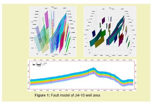
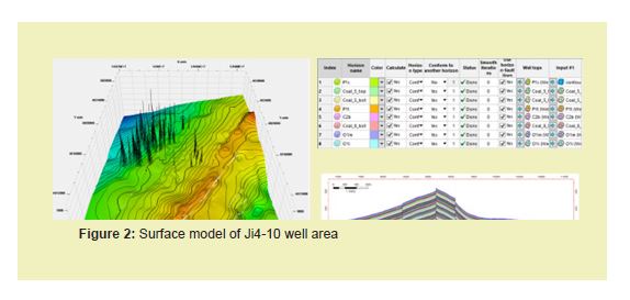
The modeling area for this study covers 250.8km², encompassing a total of 273 gas wells. Considering the comprehensive geological overview of the coalbed methane reservoir, the development status of individual coal seams, the requirements for detailed modeling, and subsequent numerical simulations, a planar grid spacing of 50m×50m is adopted for this modeling study. Vertically, the area is divided into 310 grids, with an average single-layer thickness of 1.97m. Thus, the total number of simulated grids amounts to 31,554,900 (261×390×310). Based on the model grids, 26 faults within the area are incorporated into the Petrel after being calibrated with well data. Subsequent modifications and edits are made to these faults Figure 1. The predominant trend of the faults is NNE-SSW, with lengths ranging from 699.8m to 15749.9m and throws ranging from 0.9m to 60.6m. The establishment of surface models relies on structural interpretations of coal seam interfaces, constrained by logging data for coal seams. Specifically, the seismic interpretation layer of the Shanxi Formation's No.5 coal seam serves as the model's constraint surface, while other interfaces are interpolated based on stratigraphic data or formation thickness Figure 2. In total, six surfaces are established. Vertically, the grids are determined according to the formation thickness to accurately represent thin layer characteristics, resulting in 310 vertical grids with an approximate thickness of 1.97m per grid.
Three-Dimensional facies modeling
The facies model serves as the foundation for facies-controlled property modeling.18,19 Coalbed methane, a type of unconventional natural gas, is self-generated and self-stored within coal seams, with the three-dimensional spatial distribution of coal seams exerting a controlling influence on the distribution of coalbed gas reservoirs. The establishment of coalbed facies models plays a constraining role in constructing physical parameters. Coal facies modeling is based on the identification results of coal seam logging at well points, utilizing stochastic simulation to analyze the spatial distribution of coal seams. The Taiyuan Formation to the Benxi Formation was formed in a mixed marine-continental depositional environment, primarily consisting of shallow marine shelf-barrier coast depositional systems. The sedimentary strata of the Shanxi Formation are mainly composed of delta front and pro-delta sub-facies, characterized by pro-delta mud, subaqueous distributary channels, interchannel deposits, distal sand bars, tabular sands, and peat swamp microfacies. The main coal seams were formed in a transitional marine-continental depositional environment, from bottom to top: the No.8 coal seam represents a coastal tidal flat-platform-barrier island sub-facies, predominantly characterized by median peat swamp microfacies; the No.5 coal seam represents a delta plain distributary bay-peat swamp sub-facies. The distribution of sand bodies is oriented north-south, with sediment input originating from the northern region.
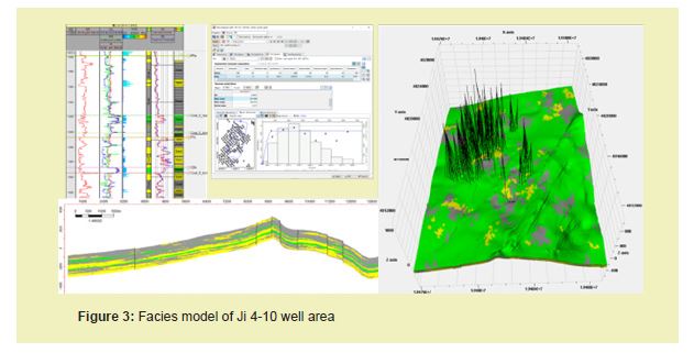
Within the modeling area, data from 269 wells were collected to interpret lithological information from well logs. Based on this data, lithology at individual wells was categorized into three sedimentary facies: sandstone, mudstone, and coal seam. Data analysis was conducted on the vertical distribution of lithology and variogram functions. In the three-dimensional geological modeling software, the lithological results from individual wells were discretized. Subsequently, the discretized lithological data underwent a normal score transformation to normalize the data. The statistical lithological data were then inputted into the lithofacies simulation module, utilizing the sequential indicator simulation method to simulate the proportions and distributions of each lithofacies. Ultimately, lithofacies models for coal, sandstone, and mudstone were established. These models are consistent with geological characteristics and demonstrate a high degree of agreement with the interpretation results of well log curves Figure 3.
Three-Dimensional property modeling
The property model of coalbed methane reservoirs refers to underground parameter models associated with coalbed methane, including porosity, permeability, gas content, hydrodynamics, reservoir pressure, and geostress models.8,20-22 The accurate establishment of property models is the ultimate goal of three-dimensional geological modeling of coalbed methane reservoirs. Property modeling entails the use of appropriate simulation methods to model property parameters at well locations and infer the inter-well distribution of these parameters.23,24 The property model of coalbed methane reservoirs is built upon the foundation of coalbed lithofacies.
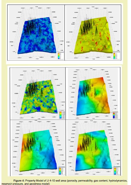
The modeling of matrix porosity adopts a facies-controlled property simulation method. In the process of porosity modeling, the variation range and distribution trends of input and output data are first statistically analyzed by lithostratigraphic sections and lithofacies. Subsequently, variogram values are utilized as constraints for unmodeled areas both horizontally and vertically. For coal and mudstone, a sequential Gaussian random simulation method constrained by lithofacies models is employed, while a deterministic modeling method is used for mudstone. Ultimately, a porosity model is established Figure 4. The simulated porosity results generally align with the distribution patterns of porosity, exhibiting distinct layering characteristics.
The accuracy of permeability models is crucial for subsequent numerical simulations. Permeability results from individual wells are indicative of coal seam burial depth. Discretization of permeability data from individual wells is followed by data analysis and variogram fitting to determine the type of variogram function for permeability, as well as the major and minor direction ranges and vertical ranges. Utilizing the Petrel three-dimensional geological modeling software, a permeability model is developed under coal seam lithofacies control based on transformed discrete permeability data Figure 4. The modeling process employs a facies-controlled property simulation method. During permeability simulation, a logarithmic transformation is initially applied to approximate its distribution to a normal distribution. Subsequently, porosity attributes are used as the second variable for trend constraint during simulation. For coal and mudstone, a collaborative sequential Gaussian random simulation method constrained by lithofacies models is utilized, while a deterministic modeling method is applied for mudstone. Ultimately, a permeability model is established.
Gas content is one of the most critical physical parameters of coalbed methane reservoirs. The foundational data for the gas content model consists of gas content data from 238 individual coal seams wells, characterized based on burial depth. Discretization of gas content data from individual wells is followed by normalization transformation in consideration of the requirements of sequential Gaussian methods for gas content data. In the Petrel three-dimensional geological modeling software, discretized gas content data undergoes normalization transformation. Subsequently, gas content variogram fitting is conducted to determine the type of variogram function for gas content, as well as the major and minor direction ranges and vertical ranges. A gas content model under coal seam lithofacies control is established using sequential Gaussian methods. The modeling process employs a facies-controlled property simulation method: sequential Gaussian random simulation method constrained by lithofacies models is utilized for coal seams, while a deterministic modeling method is applied for non-coal seams Figure 4. The simulated gas content results for coal rocks generally align with the distribution patterns of porosity.
Coalbed methane wells extract gas through depressurization induced by dewatering, and underground hydrodynamic conditions significantly impact the enrichment of coalbed methane and the development of coalbed methane wells. Based on exploration and development data of coalbed methane in the study area, the degree of coalbed methane enrichment in the study area is determined. Subsequently, the relationship between underground hydrodynamic conditions and coalbed methane enrichment is investigated. In regions with strong hydrodynamics, coal seams exhibit low gas content, while in areas with relatively weak hydrodynamic conditions or stagnant water zones, coal seams have high gas content. Based on the initial dynamic liquid level of coalbed methane wells during dewatering, combined with reservoir pressure and underground water density, the equivalent water level of each coalbed methane well is calculated. The equivalent water level of individual wells is loaded into Petrel software as point data, and contour maps of the equivalent water level are generated using the kriging interpolation method to determine the distribution characteristics of hydrodynamic planes. Based on the distribution characteristics of hydrodynamic planes, a hydrodynamic field model for the study area is ultimately established Figure 4.
The reservoir pressure of coalbed methane significantly influences factors such as gas content, gas occurrence state, and coal permeability, making it one of the crucial parameters affecting coalbed methane production. Additionally, reservoir pressure represents the energy for gas and water flow from fractures to the wellbore, serving as a vital reference for reservoir modification and process design. Utilizing the coalbed methane pressure data calculated from the aforementioned studies, discrete data points are input into Petrel software. Contour maps of coalbed methane pressure are then generated using the Kriging interpolation method, enabling the determination of the spatial distribution characteristics of coalbed methane reservoir pressure planes. Based on these characteristics, a reservoir pressure field model for the study area is established Figure 4.
The geostress in the Earth is primarily associated with various dynamic processes within the planet. Based on different causes, geostress can be classified into types such as gravitational stress, tectonic stress variations, residual stress, and induced stress (additional stress). The state of geostress not only significantly impacts the permeability of coalbed methane reservoirs but also serves as crucial parameters controlling the initiation pressure, location, and morphology of hydraulic fracturing fractures in coalbed methane wells. Building upon prior research, horizontal maximum principal stress and horizontal minimum principal stress are computed separately from well log curves. The stress computation results are then integrated as discrete data points into Petrel, and contour maps are generated using the Kriging interpolation method to identify the spatial distribution characteristics of horizontal maximum and minimum principal stresses. Subsequently, models for horizontal maximum and minimum principal stresses are established based on the spatial distribution characteristics of geostress Figure 4.
Three-Dimensional fracture modeling
The coalbed methane reservoir exhibits extremely low matrix permeability, yet is characterized by extensive cleat systems and fractures, rendering it highly heterogeneous. These features significantly influence hydraulic fracturing and production in coalbed methane wells. Fractures enhance porosity and permeability of the formation, serving as vital conduits for fluid migration. Additionally, they play crucial roles in hydrocarbon accumulation, reservoir properties, as well as sealing and compartmentalization of interlayers.
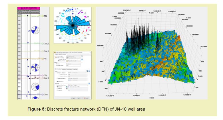
In this paper, a Discrete Fracture Network (DFN) modeling approach was employed to characterize the fracture system. Since its inception in the 1980s, DFN modeling has been extensively utilized in the field of fracture description and simulation. One of the primary advantages of this model lies in its ability to effectively address the issue of scale in fractures and integrate various sources of fracture data to obtain detailed properties of each fracture, thus offering flexibility. However, due to the inherent uncertainty in the distribution of fractures away from well locations, the stochastic simulation approach of Discrete Fracture Network heavily relies on assumptions regarding the distribution of fracture attributes, namely, the intensity of fracture development.
The shape, length, aperture, dip angle, and azimuth of fractures are determined based on comprehensive descriptions derived from various scales. Their spatial distribution is constrained by a fracture development intensity model established under multiple conditions, including distance to faults, maximum principal curvature, and distance to anticlinal axis. Fracture segments are stochastically simulated, and a discrete fracture network model is established under multiple conditions and scales Figure 5. Subsequently, the fracture model is upscaled to obtain equivalent fracture porosity and permeability.
Through using advanced three-dimensional geological modeling techniques, the accurate characterization of the lateral and vertical heterogeneity of coal seams can be achieved. Fine-scale three-dimensional geological modeling of coal seams encompasses structural modeling, facies modeling, petrophysical modeling, and fracture modeling. By integrating dynamic and static data, employing multi-scale information, and constraining the model with multiple attributes, the precision of the model is enhanced, aligning its results more closely with actual subsurface conditions.
The application of fine-scale three-dimensional geological modeling techniques has shown good results in coalbed methane description. Models incorporating attributes such as porosity, permeability, gas content, hydrodynamics, reservoir pressure, and geostress have been established for the Ji4-10 well area. These models predict the spatial distribution characteristics of various attributes, providing a basis for delineating favorable development areas and deploying well locations.
None.
This Research Article received no external funding.
Regarding the publication of this article, the authors declare that they have no conflict of interest.

